Mid Lachlan Landcare
supporting sustainable agriculture and restoring the environment
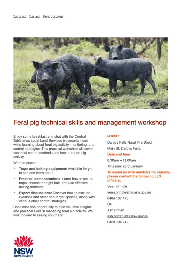
Are Feral Pigs A Problem At Your Place?
UPDATE 20th January 2025
This event has been postponed and will now NOT be running in January. A new date will be advised as soon as possible.
Contact Ash or Sean for more information.
Upcoming workshop in Darbys Falls, NSW hosted by Local Land Services.
Feral pigs act like bulldozers in the bush, breaking through fences, rooting up crops, disturbing soils and changing a sites hydrology. Under the NSW Biosecurity Act 2015 every landholder has a General Biosecurity Duty to reduce risks caused by feral pigs by undertaking control activities. This workshop will help equip you to meet your obligations and stop pigs in their tracks.
Education Tours: HSc Food Technology & Hospitality Paddock-to-Plate
Educational field trips make up a core part of Mid Lachlan Landcare’s remit and at this time of the year, it’s all about Paddock-to-Plate.
Students studying Food Technology and Hospitality are required to learn about many issues that can be demonstrated on-farm. Topics such as land cultivation; food nutrition and safety; ethical food production; food chain resilience and food security; product research & development; consumer influences (food choices) and waste management are all topics our farming community are well versed in and can deliver insights and solutions too based on their experience and business management practices.
Get in touch if you’d like us to organise an educational tour for your group.
Beetle Watch. Biological Control of St John’s Wort.
We’ve started this week with a little Beetle Mania after being informed that swarms of St John’s wort beetles had been spotted at a property just outside Canowindra!
St John’s wort was introduced into Australia in the late 1800’s primarily for use as a medicinal plant. Like many other early imports, this sunshine yellow botanical escaped its original confines to become naturalised. It now featured on the NSW WeedWise list and is a relatively common weed in paddocks and public sites across large swathes of southern and eastern Australia.

One of the most immediately impactful consequences of this weed is felt in the way its chemistry affects livestock, in particular cattle and horses. The plant contains two key ‘medicinal’ actives – hypericin produced in the flower stems as they grow in spring, and hyperforin which is concentrated in new stem growth.
Both Hypericin and Hyperforin impact the brain by changing the way it takes up signalling chemicals (dopamine, seratonin etc) and their presence is why the plant has a traditional use as an anti-depressant. These chemicals impact stock behaviour too as well as causing their skin to become more sun-sensitive (photosensitive) and prone to heat stress which in turn reduces vigor. Finally, there’s also a serious risk of long-term liver damage with prolonged grazing, especially when the plant is grazed during its growth phase. Here’s some more information from Meat & Livestock Australia and a more in-depth report into the impacts on animal health of St John’s Wort here.
So what about these beetles?
From 1928 15 biocontrol agents were studied with a view to bringing this weed back under control. Of those, the following have stood the test of time as effective biological control agents:
Lesser St John’s wort Beetle (Chrysolina hyperici) – Native to Europe and West Asia.
Greater St John’s wort beetle (C.quadrigemina) native to parts of Europe and Africa.
- Both imported by DSIR in 1943 and 1965.
- Both can be found in infestations in most places & they are very hard to distinguish between.
Eriophyd mite (Aculus hyperici)
Root feeding beetle (Agrilus hyperici)
phloem feeding aphid (Aphis chloris)
and a gall forming fly (Zeuxidiplosis Giardia)
One of our Landcare members was lucky enough to find themselves hosting a St John’s wort beetle party last week and took some photos to show us:
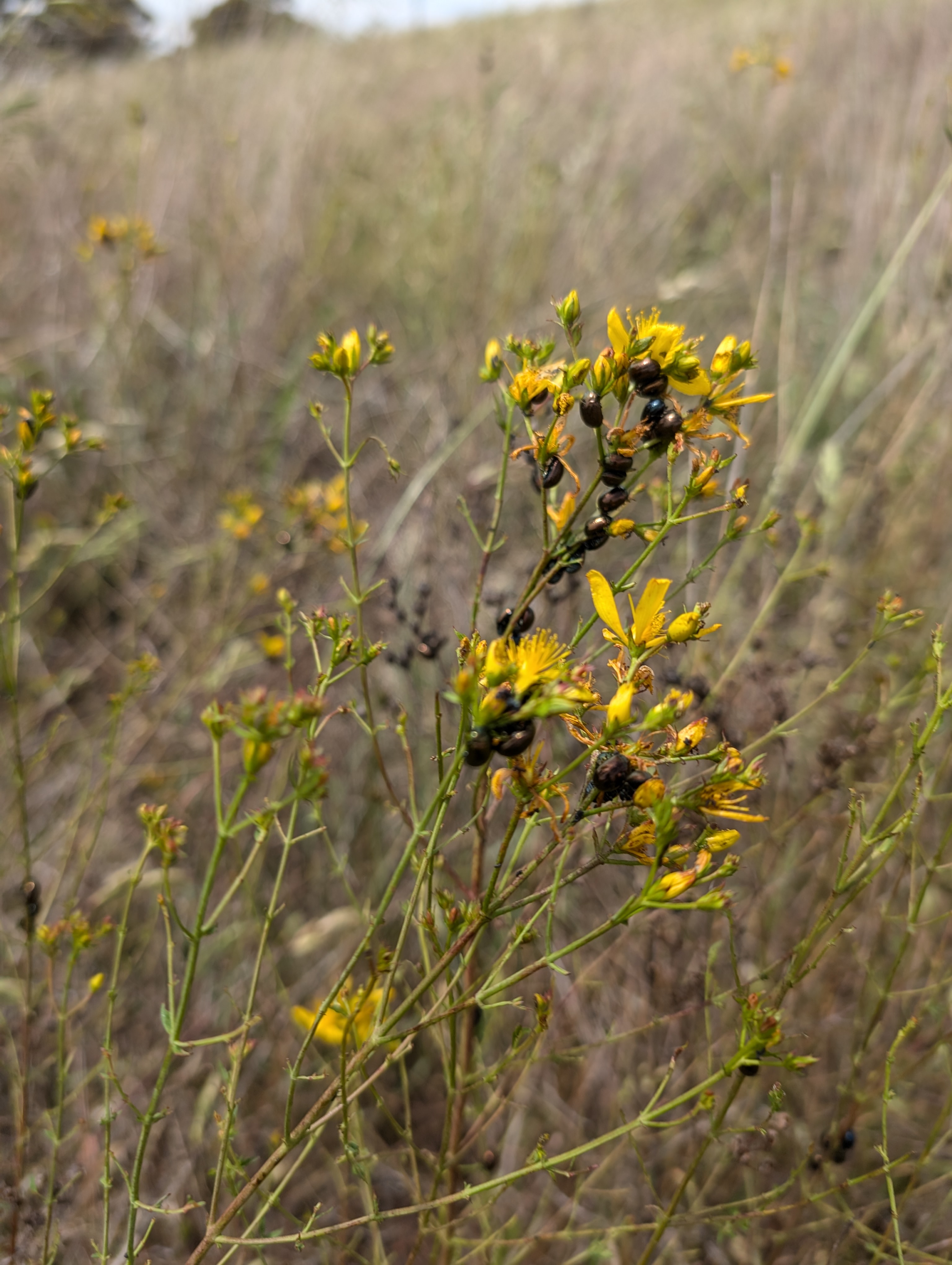
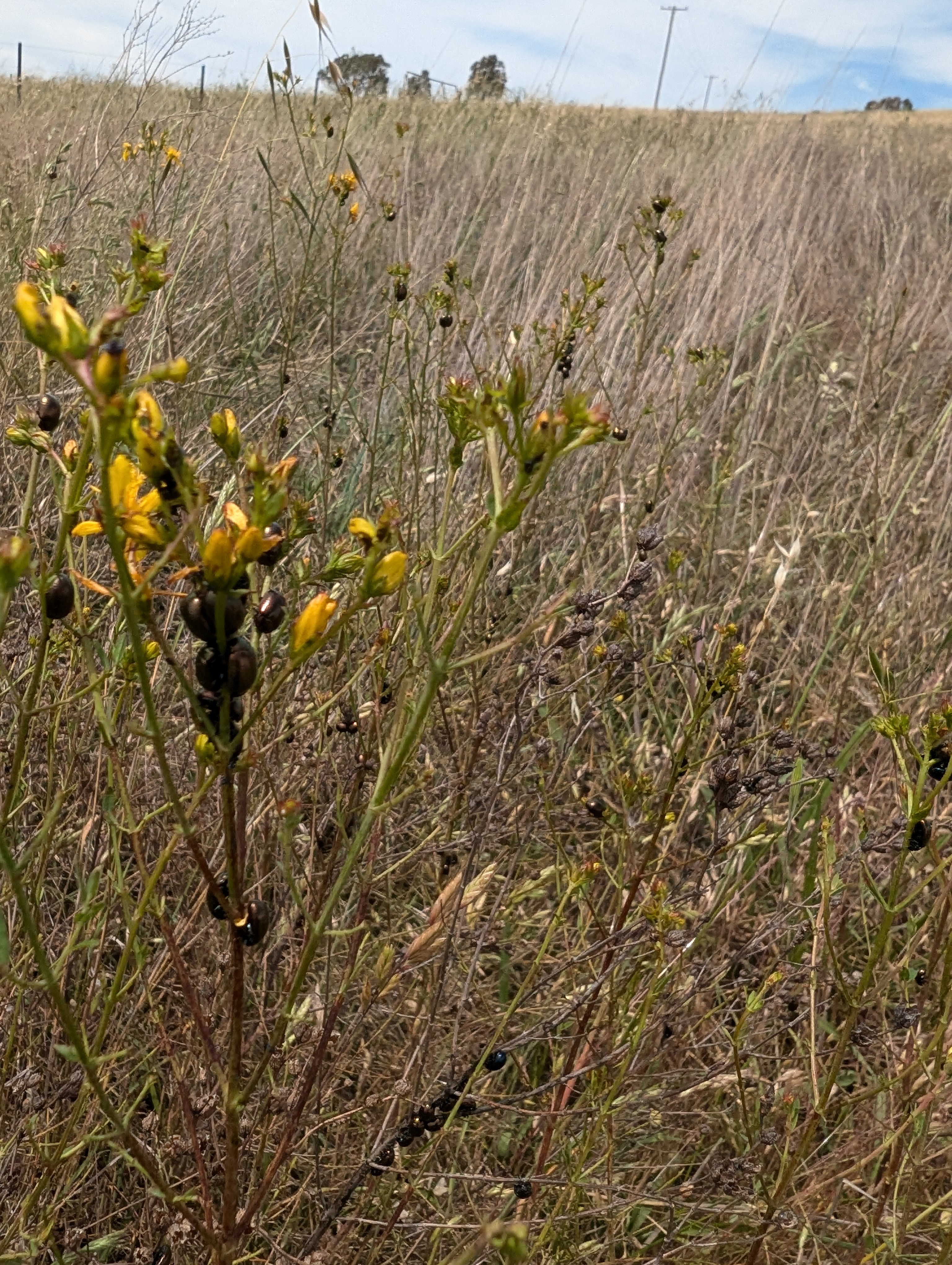
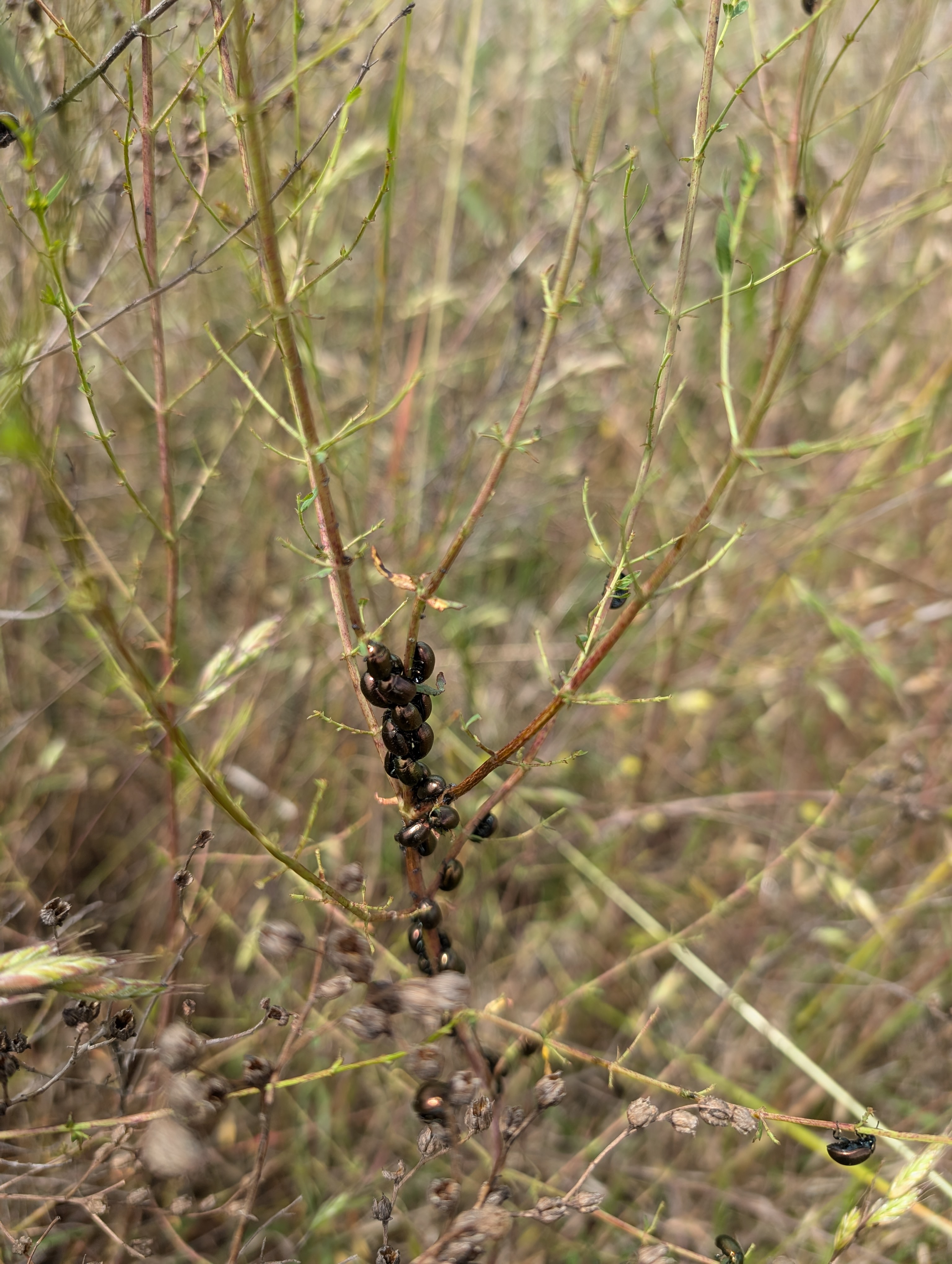
Adults and larvae totally defoliate the plants, suppressing flowering and seed production. This dramatically reduces the plants chance of survival. With enough beetles, the weed can be managed entirely this way but that often does not happen as beetles come and go as they please!
Citizen Science – get involved!
Whether you’ve got these beetles at your place or are longing for some, there’s a citizen science project that might be of help!
Atlas of Living Australia has an ongoing project capturing data on St John’s wort beetle sightings and activity. While it might sometimes seem like one sighting won’t make any difference to these country-wide projects, that’s not true. It would be great to see all biological control beetle sightings listed so we can track their movements and plan our management strategies in advance, potentially helping reduce insecticide use and subsequent cost.
If you’d like to upload your data but are not sure how to/ need help then get in touch with us and we’ll help you work through it all.
Here’s the link to the St John’s wort biocontrol hub.

Sharing beetles.
Find yourself with a visit from these beetles and want to help out a neighbour or friend? That’s entirely possible!
We found some great information and tips on this Landcare NZ site: https://www.landcareresearch.co.nz/discover-our-research/biodiversity-biosecurity/weed-biocontrol/projects-agents/biocontrol-agents/st-johns-wort-beetle/
- Move beetles around in Autumn after their summer hibernation – March for greater and April to late may for lesser.
- The best time to find them is around dusk.
- Collect stems and beetles in a box and place them at new site.
- At least 100 are needed for new colony.
- Release on a paddock that’s not heavily grazed.
A Day In The Life of A Landcare Coordinator
For many, mention Landcare and the image of a smiley faced human planting trees comes to mind! While that’s part true, it’s definitely not the only thing us Landcare folks get up to.
2024 is the first of the four-year Landcare Enabling Program from Landcare NSW. A program that has provided funding for full-time co-ordinators and regional administration support.
Here at Mid Lachlan, we opted to split one full-time coordinator role into two so that our team would have plenty of time for special interest Landcare projects and their own bush conservation/ farming enterprises and hobbies. Join Amanda as she takes us with her on a morning of Landcaring around the Cowra and Canowindra region and keep your eye on the Landcare NSW website for current vacancies: https://landcarensw.org.au/careers/
- https://odonata.org.au/ and their work with E(Environmental)DNA collection.
- Age of Fishes Museum Canowindra
- National Tree Day
- Landcare NSW and the Landcare Enabling Program
On the Search for Bathursts Earless Dragons
Being English, the only dragons I grew up around were mythical, the villains in our ancient ledgends…
I was 20 before I saw my first real dragon, possibly a Frill-necked Lizard – Chlamydosaurus kingii, while backpacking through Australia’s Northern Territory. I spotted it while exploring Alice Springs as I killed time, waiting for the Greyhound bus to roll back through. I still remember the awe that rose within me as I watched it frill-up before scampering off into a tree*. I’d only landed in Australia that month and was already experiencing this vast, dusty and deep orange landscape as other-worldly. After this encounter, I felt like I’d time-travelled to the land of the dinosaurs and it felt awesome!
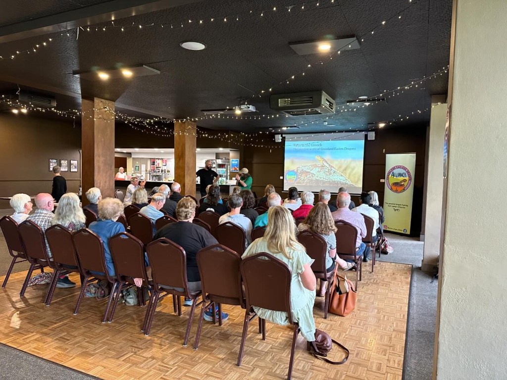
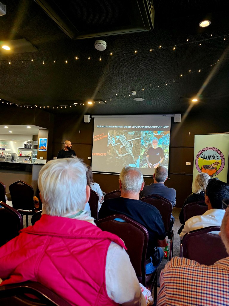
Thirty years later and I find myself in the back room of a bowling club in Bathurst, waiting to be introduced to the Grassland Earless Dragon and I can’t contain my excitement!
————————-
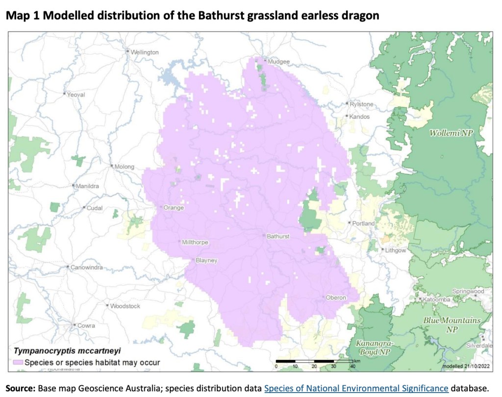
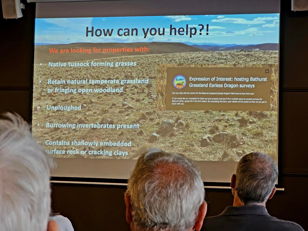
The Earless Dragon we’re discussing (Tympanocryptis mccartneyi) is tiny with a maximum body length of 16cm. It’s also critically endangered and very tricky to spot given its preference for burrowing down with Wolf spiders and hiding out under rocks – not that any of that dented the spirits of the Grassland Earless Dragon Alliance!
One of the key reasons these dragons are so vulnerable is habitat fragmentation. They exist over very small home ranges which typically extend to a few hundred meters per dragon and make their homes in rocky, tussucked grasslands located on alluvial plains (the pink area below). The presence of surface rocks are critical, serving as refugee from predators and trampling hooves, breeding spots and basking spaces.
Ecologist George Madani from the Grassland Earless Dragon Alliance presented what I can only describe as the best Citizen Science-led research I’ve ever seen. The team applied an ingenous, low-stress (for the Dragons at least) method of tracking these creatures by utilising fake spider holes in the form of little tubes that they place in the landscape, quadrant style, and monitor from season to season. We were shown data supporting how these man-made burrows have increased the chances of locating the dragons and how this system has enabled the team to prove the life-span of this species is closer to 5 years rather than the 1-3 quoted in earlier literature. All in all it was a thoroughly enjoyable presentation and one that presented opportunities for both farmers and Landcarers in our region to get involved in.
Want to be involved in this Dragon Quest?
Evidence is pointing towards a positive relationship between sheep grazed grasslands and the dragons. Both sheep and dragons thrive in these rockier, tussuck-like areas and the dragons prefer their grasslands to be grazed down rather than over-grown as this makes it easier for them to move through the landscape.

If you are located in the pink area (for Mid Lachlan Landcarers that’s the Millthorpe, Blayney, Neville, Barry, Newbridge, Lyndhurst) and have rocky, tussuck paddocks at yours, give some thought to whether you could host a dragon survey at your place. You can contact the Alliance directly or drop us a line and we’ll put you in touch.
Keep In Touch
You can follow the Grassland Earless Dragon Alliance on Social Media via their Instragram and Facebook accounts.
You can read some of George Madani’s research here.
This talk was organised by Greening Bathurst as part of their ‘Green Drinks’ series of events. It was hosted by Central Tablelands Regional Landcare on Wiradjuri land, Bathurst
*Apparently it’s unlikely my first dragon spot was the frill neck lizard in Alice as they don’t travel down that far. It’s likely I saw that further north but in any case, Australias reptiles certainly captured my imagination!
Citizen Science: Frog Hunting
Last night was great for a little frog spotting with the moon giving us just enough to light a path to the farm dam. The audio and photographs in this short video clip were recorded last night and as you can tell, the frogs were quite active (and numerous) which is a good sign.
Frogs play an important role in the food chain, predating on insects while being prey for birds and snakes!
Farm dams such as this one can be made frog-friendly by planting native grasses, sedges and wattles around the edges, creating a year-round habitat to hunt, breed and shelter in. As the weather gets colder frogs will hibernate under stones and wood piles, so don’t be too quick in clearing fallen timber around the dam!
The frogs pictured are Peron’s Tree frogs, Litoria peronii, a large species of frog that can reach up to 7cm long. The yellow colouration on the thighs is a key identifying feature as is the call which some say sounds like a cackling laugh.
To help us identify this frog we used the Frog ID app which can be downloaded for free by following this link. The app has a ‘frogs near me’ feature and also has an extensive dataset of calls for each frog species and calls can be recorded directly into the app for ease of identification.
The Frog ID app is one of a growing number of Citizen Science empowerment tools playing a part in enhancing our understanding of the natural world. If you want to know more, get a bit of help understanding how this and other citizen science aps work or just chat through what you’ve found, get in touch with us at Mid Lachlan Landcare. We’re happy to help!
This particular dam is situated on a Box Gum Grassy Woodland site in Woodstock, near Cowra, NSW.
Soil’s Alive! Springtails Under the Microscope
This little critter is a member of the springtail family of soil organisms. It’s about 1.75mm long and is clinging to a soil aggregate on our microscope slide!
Springtails feed on rotting plant material and fungi. A high abundance and diversity of springtails in soil is a measure of its health.
2024 has been a year of encouraging our community to get up close and personal with their soil’s macro and microorganisms because things grow better when your soil is alive!
Book now for our 2024 AGM and Christmas catch up
We hope you can make it along to our Christmas catchup and AGM at the Age of Fishes myseum in Canowindra on Wednesday 27th November from 5.30pm.
This year we are excited to announce that the event will be catered by Gerald Power of Indigenous Cultural Adventures. Gerald founded this company in September 2016, with a vision to share the heritage and cultural knowledge of the region’s Wiradjuri nation with both visitors and residents alike. Indigenous Cultural Adventures is based in Orange, and has been established with the blessing and approval of local Wiradjuri Elders. “We wish to take the public on a journey about the First Nations People, and it’s about sharing our culture and heritage through experience of our country and the food that we have consumed and survived on for 50,000 years,” explains Gerald.
Dinner cost is $30pp for a 3-course meal and Gerald will also have a chat with us about himself and his Company.
Please bring your own drinks and cups/glasses.
Our Christmas catchups are a bit of a tradition now and we look forward to seeing you there. Numbers are limited so please book your tickets ASAP by following this link.
A night in the woods watching Squirrel Gliders
Landcare is often thought of in terms of our ‘doings’ and that’s fair, but sometimes, it’s important to focus ones attention on being – being quiet, being alert and being in the right place at the right time.
Last week I received a call from our daugher. She’s staying at our Box Gum Grassy Woodland block out near Woodstock at the moment and had been watching squirrel gliders moving about our ‘home’ paddock all evening – she was very excited at having caught the performance!
When we moved to the land about ten years ago we erected a lean-to on an old shed so we could sit out at night. Back then we had witnessed gliders landing on the structure from time to time, but as they realised we were staying, they changed their route and left us well alone.
Our next encounter with these cute fluffy creatures was July this year when we found two squirrel glider tails – one large, one smaller, under what we now know to be the nest tree and the first ‘glide’ tree out on our home paddock. Owls are a natural predator of Squirrel Gliders and it’s possible we’d stumbled upon the unwanted part of their dinner – a reasonable explanation given the evidence and more hopeful than thinking they’d fallen foul of a ferral cat or fox (both of which are also entirely possible)…
Fast forward to this last two weeks and things, including our eyeballs, are looking up again and as is often the case, two sets of eyes are better than one! This week we sat out at dusk to observe the nest tree in the hope that we’d spot the gliders emerging and taking their first glide. Well we were in luck, and after a patient (and quiet) twenty minutes of watching we caught our first glimpse, with three gliders coming out and gliding away from us towards our neighbours property and one gliding right towards us!
Squirrel Gliders need tall old trees both to nest in and glide from. According to research published by the Australian Journay of Zoology in 2009 (1), they glide at an angle of around 28.5 degrees and generally launch from a horizontal position just under 2m from the top of the tree. This certainly fits with what we observed, or at least it appeared to given we were equip only with our eyes and phone cameras (no flash). The glider we tracked travelled 28.8m, 14.3m and then 21.2meters per glide before we lost track of them!
I’ve captured our squirrel glider evening in this short video presentation. You can pause the show to read the slides if needed. At this moment in time, squirrel gliders such as these are classified as vulnerable but not endangered. I am not aware of any specific citizen science projects monitoring glider behaviour in our area at this time but that doesn’t mean to say there won’t be something in future so we’ll keep you posted. In the meantime, why not spend a few minutes around dusk or dawn and see what you can spot!
Here’s a short look at the angle of glide for one of the Squirrel Gliders we observed.
Reference:
- Goldingay, Ross & Taylor, Brendan. (2009). Gliding performance and its relevance to gap crossing by the squirrel glider ( Petaurus norfolcensis ). Ross L Goldingay. 57. 10.1071/ZO09003. Gliding mammals occur worldwide and many are subject to increasing levels of habitat fragmentation. Knowledge of their ability to cross tree-gaps by gliding is quite poor. We describe aspects of the gliding performance of the squirrel glider (Petaurus norfolcensis) based on recorded parameters of 85 glides of 73 individuals. Animals launched from a horizontal position ~1.7 m below the top of a tree and 2.3 m out from the main trunk. All but one glide was to the trunk of a tree, landing 5.7 m above the ground. Animals glided a mean of 21.5 ± 0.9 m (range 9–47 m) in a horizontal plane, with no significant difference between the sexes. Horizontal glide distance appears to reflect tree spacing where individuals were released. The mean glide angle was 28.5 ± 0.8°, with no significant difference between the sexes. We predict that trees beside roads that create a tree-gap of 20 m (two-lane road) or 43 m (four-lane road) will need to be a least 13 m and 25 m tall, respectively, to enable animals to safely glide across a road. Where trees are absent, 12-m-high wooden poles could be installed, requiring some in the median strip of four-lane roads.
Our Soil Microbiology Project Goes Global!
We know it’s a big week for our friends over in the USA but did not expect to wake up this morning and find nearly 1000 of them had landed on our little old website!
Turns out the good people at Soil microbe testing kit company microBIOMETER had featured our study in their latest newsletter. How very exciting!
We’re hoping our American brothers & sisters see how great the Cowra region is and come on over for their next tree-planting, soil-testing vacation. Maybe we could treat them to one of our legendary paddock-to-plate tours…
Here’s a snippet from the newsletter along with a picture of the stats from our website this morning. The full newsletter can be found here.


Our soil microbiology testing was possible thanks to the shared work of the NSW Biodiversity Conservation Trust and Landcare NSW under the Private Land Conservation Matters project.


